
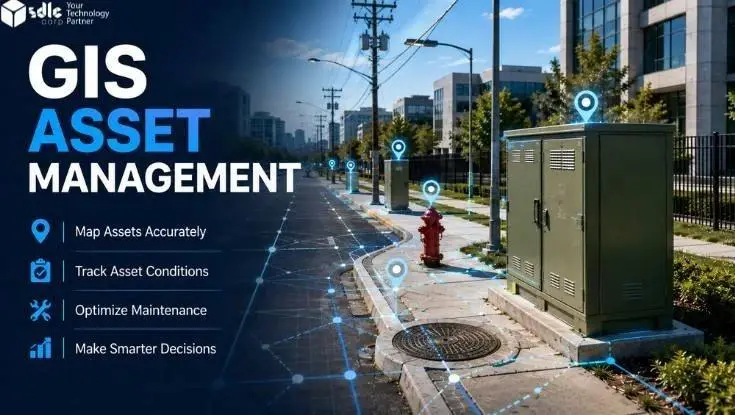
Asset data often sits across GIS, EAM, and field systems. GIS manages location and network context, while EAM tracks maintenance, costs, and work orders.
GIS asset management connects these records around the same physical asset, helping teams coordinate location, condition, maintenance, and field updates more effectively.
Key Takeaways
- GIS provides location, geometry, network relationships, and spatial context for assets.
- EAM manages work orders, maintenance plans, labor, materials, costs, and lifecycle history.
- Field workflows capture inspections, readings, photos, repairs, and condition changes at the asset location.
- Integration should move only the data that another workflow needs.
- A persistent asset ID should connect the same asset across GIS, EAM, and field records.
- Validation and approval should control changes before they update an authoritative record.
What Is GIS Asset Management?
Geographic Information System (GIS) asset management combines geospatial data with operational asset information. It helps teams manage physical assets using location, condition, relationships, maintenance history, and field activity. Therefore, it goes beyond placing points on a map.
A useful GIS asset record may include coordinates, geometry, asset class, condition, and network position. Meanwhile, an EAM record may hold work history, costs, labor, parts, warranties, and maintenance plans. Integration connects these views without forcing both systems to store every field.
In real enterprise environments, the GIS layer may use Esri ArcGIS, while maintenance and lifecycle work may run in an EAM platform such as IBM Maximo Application Suite. Naming the platforms does not change the ownership model: GIS remains focused on spatial context, while EAM manages work, maintenance, cost, and lifecycle records.
Organizations use this approach for distributed or location-dependent assets. Common examples include water valves, hydrants, pipelines, roads, streetlights, substations, fiber networks, signs, and facilities. In each case, location affects how teams inspect, maintain, prioritize, or replace the asset.
GIS Asset Management vs Traditional Asset Tracking
- Traditional Asset Tracking
Tracks what the organization owns and connects basic records to each item.
- GIS Asset Management
Adds proximity, service areas, network context, access routes, and spatial relationships to the asset record.
For example, an asset list may show 200 valves that need inspection. GIS can show which valves sit in the same service zone and which crews can reach them efficiently. EAM can then track the resulting work, labor, materials, and completion history.
GIS vs EAM vs Field Workflows:
What Does Each Manage?
GIS, Enterprise Asset Management (EAM), and field tools should support the same asset without duplicating every responsibility. In practice, each platform works best when it owns the data closest to its purpose. Shared identifiers then connect the records. If asset data also connects with finance, procurement, inventory, or other business functions, understanding what ERP is can help clarify its role alongside GIS and EAM.
For connected utility and telecom networks, Esri ArcGIS Utility Network provides a governed network model for connectivity, topology, and asset relationships.
GIS - Asset location and coordinates
- Point, line, or polygon geometry
- Network connectivity and topology
- Spatial relationships
- Service areas and operational zones
EAM - Work orders
- Preventive maintenance schedules
- Labor and technician time
- Materials and spare parts
- Maintenance costs and history
Field Workflow - Inspection results
- Photos and attachments
- Meter or sensor readings
- Condition updates
- Repair notes and GPS verification
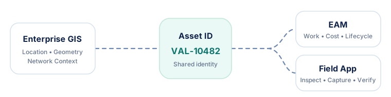
GIS vs EAM vs Field Responsibility Table
| Asset data | GIS | EAM | Field workflow |
|---|---|---|---|
| Asset ID | Shared identifier | Shared identifier | References ID |
| Geometry | Primary owner | References | Captures proposed changes |
| Location | Primary owner | References | Verifies or updates |
| Network relationship | Primary owner | References | Views |
| Work order | References | Primary owner | Executes |
| Labor and materials | Limited reference | Primary owner | Captures usage |
| Maintenance history | References | Primary owner | Adds completed work |
| Condition | Shared by rule | Stores lifecycle view | Captures observations |
| Inspection result | References as needed | Stores work record | Captures result |
| Photos | Links or references | Links or stores | Captures evidence |
What Data Should GIS and
EAM Own?
The system-of-record principle defines which platform has authority for a data element. For example, GIS may own geometry while EAM owns work-order status. Other systems can reference or receive that information, but they should not silently overwrite it.
The ownership model may also vary across different types of ERP systems, especially when asset management, inventory, procurement, and finance run on one integrated platform.
This decision should come before API design. Otherwise, teams may create two-way synchronization without deciding which value wins during a conflict. As a result, a technically successful integration can still produce unreliable asset records.
| Data domain | Typical authority | Reason |
|---|---|---|
| Geometry and coordinates | GIS | Spatial editing and network rules belong in GIS |
| Asset maintenance plan | EAM | Maintenance scheduling belongs in EAM |
| Work-order status | EAM | EAM controls work execution and history |
| Labor and material cost | EAM | EAM tracks resource and cost records |
| Field observation | Field workflow, then governed system | Technician captures the observation first |
| Condition score | Defined by governance rule | May depend on inspection and lifecycle processes |
| Photos and evidence | Document store, EAM, or shared service | Ownership depends on retention needs |
| Asset identifier | Enterprise-wide shared key | All systems need the same identity |
Why Persistent Asset IDs Matter
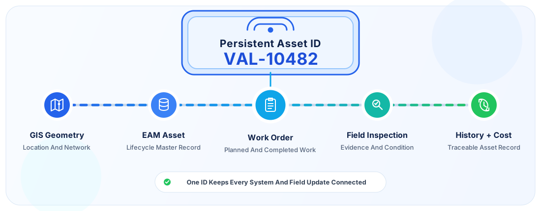
A persistent asset ID lets different systems refer to the same physical object. For example, VAL-10482 can identify one water valve in GIS, EAM, field forms, inspection history, and reporting systems.
How Field Workflows Connect GIS and EAM
Field workflows turn enterprise records into actionable work. A technician needs enough context to find the right asset, understand the task, complete it, and record evidence. Afterward, the organization needs a controlled way to return those results to GIS and EAM.
For example, ArcGIS Field Maps supports map-based field access and data capture, while IBM Maximo Mobile supports role-based field work and asset execution.
What Field Teams Need
Context Mobile maps, asset history, work-order scope, priority, and GPS verification.
Capture Simple forms, required fields, photos, offline access, and clear synchronization status.
End-to-End GIS–EAM–Field Workflow Example
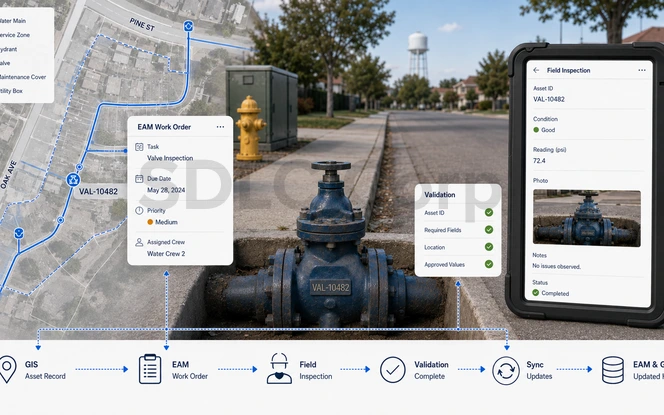
A water valve inspection shows how the three layers can work together without duplicating responsibilities.
Asset Record Exists in GIS: GIS stores valve VAL-10482 with its location, geometry, service zone, and network relationships.
EAM Generates a Work Order: A preventive maintenance schedule creates an inspection task, due date, priority, and assigned crew.
Technician Receives the Assignment: The field application displays the valve on a map with work instructions and selected history.
Technician Inspects the Asset: The technician records condition, readings, photos, repair findings, and notes.
Data Is Validated: Required fields, allowed values, asset ID, and location rules are checked before approval.
GIS and EAM Synchronize: EAM receives the completed work result, while GIS receives approved spatial or governed changes.
Asset History Is Updated: Inspection, maintenance, condition, and cost stay linked through the persistent asset ID.
Offline Field Work, Validation, and Synchronization
Asset crews often work in basements, rural corridors, plants, tunnels, or remote networks. Therefore, a field workflow should not depend on continuous connectivity. Modern GIS field tools can package map areas and editable data for offline work, then synchronize updates later.
For implementation guidance, Esri documents how to prepare ArcGIS Field Maps for offline use, while IBM explains Maximo Mobile authentication and offline data flow.
How Offline Field Workflows Operate
Validate Before Updating Authoritative Records
Field data reflects what technicians see, but not every observation should immediately change the master record. Therefore, organizations can use Field Update → Validation → Approval → System-of-Record Update .
How to Handle Synchronization Conflicts
Conflict Example GIS shows a valve as active, field inspection marks it failed, while EAM has an open emergency work order.
Resolution Rules Compare timestamps, ownership rules, version data, approval status, and the business meaning of each value.
Common GIS Asset Management Integration Problems
Work orders can attach to the wrong record when GIS and EAM use inconsistent identifiers.
Duplicate records distort asset counts, maintenance history, and risk analysis.
Two systems may overwrite each other when both think they control the same field.
Technicians can inspect retired, moved, or already repaired assets when downloaded data is old.
Validation errors, network issues, API limits, or mapping changes can stop updates.
Offline edits can conflict when several users update the same asset.
Different code sets can make the same asset appear active in one system and out of service in another.
A sync job can appear successful while still rejecting individual records.
How to Test GIS–EAM Integration Before Go-Live
Testing should cover the full workflow, not only individual API calls. A successful test proves that the same asset can move through GIS, EAM, and field processes without losing identity, status, or history.
Esri's Utility Network integrations overview is a useful reference for identifying integration strategies and APIs that may need regression coverage.
Confirm that the same persistent asset ID resolves in GIS, EAM, middleware, and the field application. Also test renamed, retired, missing-ID, and duplicate-ID records.
Change shared attributes in each system and confirm that the authoritative source wins. Geometry and maintenance status should follow the ownership model defined before integration.
Create, assign, dispatch, complete, and close a work order. Then verify that history, labor, parts, condition, and status update in the correct systems.
Take a field device offline, update an asset, and reconnect it. Version checks should detect competing edits and prevent silent overwrites.
Simulate timeouts, invalid records, duplicate messages, interrupted uploads, and unavailable services. Safe failures should retry, while unresolved records should enter a review queue.
Submit a location or geometry correction from the field. Confirm that the update passes through the required review and validation process before GIS changes.
Run regression tests before GIS, EAM, middleware, or mobile-platform upgrades. Check authentication, API versions, field mappings, event schemas, scheduled jobs, and error handling before production release.
Use real asset classes and realistic field scenarios. Release only after the end-to-end workflow can preserve asset identity, recover from failures, synchronize safely, and trace each update to its source.
How to Implement GIS Asset Management Successfully
A successful program starts with workflows and data responsibility rather than software selection. The following sequence helps teams reduce integration risk.
Teams planning a broader enterprise rollout can follow a structured ERP implementation process to coordinate governance, data preparation, integration testing, phased deployment, and user adoption.
The business case should also account for software licenses, integration development, data migration, testing, training, support, and long-term maintenance. This ERP cost guide explains the major cost categories involved in a broader enterprise rollout.
For asset-management governance, teams can also use ISO 55000:2024 as a reference for asset-management vocabulary, principles, lifecycle thinking, value, and organizational alignment. The standard does not prescribe a GIS–EAM architecture, but it provides a useful management framework for the ownership, risk, and lifecycle decisions that architecture must support.
- Define Asset Classes
Identify geometry type, required attributes, maintenance needs, criticality, and lifecycle rules.
- Establish Data Ownership
Decide which system owns each important data domain and who may approve changes.
- Standardize Asset IDs
Create a persistent identifier strategy before linking systems.
- Map Integration Workflows
Define source, destination, trigger, fields, validation rules, latency, and error handling.
- Design Field Workflows
Build forms and screens around technician tasks and required evidence.
- Add Validation and Governance
Use domains, geometry rules, approvals, and audit history.
- Test Offline and Synchronization Scenarios
Test weak connectivity, stale downloads, failed APIs, and competing edits.
- Monitor Integration Health
Track interface latency, failed records, retry volume, and stale data.
How to Measure GIS Asset Management Performance
Teams should measure operational outcomes and data quality together. A fast work-order process has limited value when technicians use incorrect asset locations. Likewise, perfect maps do not help when maintenance work remains delayed.
Teams that track physical equipment can also use equipment usage and maintenance tracking to connect service history, utilization, repair activity, and maintenance performance.
GIS Asset Management Architecture at a Glance
A simple architecture keeps system responsibilities visible. The integration layer can handle transformation, validation, routing, retries, logging, and monitoring.
When GIS data must move across vendor boundaries, open geospatial interfaces can reduce dependence on proprietary exchange formats. The OGC Web Map Service (WMS) standard defines a common way to request map images, while the OGC Web Feature Service (WFS) standard supports feature-level access to geospatial information. These standards can complement APIs and middleware in a GIS–EAM integration architecture.
For newer web-API patterns, the OGC API – Features standard provides modern API building blocks for fine-grained geospatial feature access.
When Do You Need GIS and EAM Together?
Not every organization needs a complex integration. GIS alone may be enough when the main requirement is mapping and spatial analysis. EAM alone may work when location adds little value to maintenance decisions.
However, organizations benefit from both systems when location and maintenance processes depend on each other.
| Requirement | GIS | EAM | GIS + EAM |
|---|---|---|---|
| Map asset locations | ✓ | ||
| Analyze spatial relationships | ✓ | ||
| Track maintenance costs | ✓ | ||
| Manage labor and materials | ✓ | ||
| Manage preventive maintenance | ✓ | ||
| Map open work orders | ✓ | ||
| Dispatch crews by location | ✓ | ||
| Maintain distributed infrastructure | ✓ | ||
| Combine condition, location, and work history | ✓ |
The integration becomes especially valuable for utilities, public works, transportation, telecom, energy, and large facilities. In these environments, crews need both spatial context and reliable maintenance history.
Connect GIS, EAM, and Field Operations Around One Asset Record
A successful asset-management workflow needs clear ownership, reliable integration, and field processes that technicians can actually use.
Talk to an ExpertConclusion
GIS asset management works best when GIS, EAM, and field tools share an asset identity without duplicating every responsibility. GIS should manage spatial truth, while EAM should manage work and lifecycle records. Field workflows should capture current conditions and completed activity.
Therefore, the integration strategy should start with asset IDs, data ownership, and workflow rules. APIs and synchronization come afterward. When teams also add offline support, validation, monitoring, and conflict handling, asset records become more reliable across the full lifecycle.
Frequently Asked Questions
What Is GIS Asset Management?
GIS asset management combines geospatial information with asset condition, maintenance, and operational records. It helps teams understand where assets are, how they relate spatially, and what work they require.
What Is The Difference Between GIS And EAM?
GIS manages spatial information such as location, geometry, and network relationships. EAM manages work orders, maintenance plans, labor, materials, costs, and lifecycle history. Therefore, the systems usually complement each other rather than replace each other.
Can GIS Replace An EAM System?
GIS can support asset inventories, inspections, and spatial workflows, but it does not always replace full EAM functions. Organizations that need detailed maintenance planning, cost tracking, labor management, and lifecycle records often still need EAM.
How Does GIS Integrate With EAM?
GIS and EAM can integrate through APIs, middleware, scheduled synchronization, or event-driven services. A persistent asset ID links records, while ownership rules determine which system can update each data element.
Which System Should Own Asset Data?
Ownership depends on the data domain. GIS typically owns geometry and spatial relationships, while EAM usually owns work orders, maintenance history, labor, and costs. Shared fields need one authority or a clear conflict rule.
How Do Field Technicians Update GIS And EAM Records?
Technicians use mobile workflows to inspect assets, capture readings, add photos, record repairs, and update condition. After validation, approved changes synchronize to GIS, EAM, or both according to data-ownership rules.
Can GIS And EAM Workflows Work Offline?
Yes. Field applications can download maps, forms, and assigned records for offline use. After connectivity returns, technicians can synchronize their changes, provided the organization has defined conflict and validation rules.
Why Is A Persistent Asset ID Important?
A persistent ID lets GIS, EAM, field apps, work orders, and inspection records refer to the same physical asset. Therefore, it reduces mismatches and supports reliable lifecycle history.
What Data Should Be Synchronized Between GIS And EAM?
Teams should synchronize only data required by another workflow. Common examples include asset IDs, location references, lifecycle status, condition, and work-order context. Ownership rules should decide which direction each field moves.
What Are The Biggest GIS–EAM Integration Challenges?
Common problems include mismatched asset IDs, duplicate records, unclear ownership, stale field data, failed synchronization, offline conflicts, and inconsistent status values. Strong governance and interface monitoring help teams control these risks.